 Book your next hiking trip
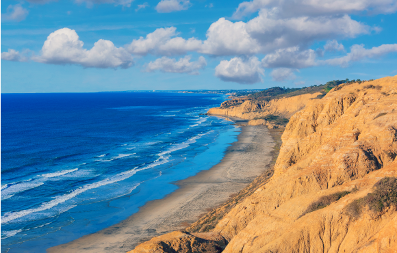
Parry Grove Trail, Torrey Pines State Natural Reserve
San Diego, Calif. 1 of 6
Length: Varies
Getting There: Take Highway 101 and follow the signs for Torrey Pines State Beach. Park along the beach and walk along the sand until you reach the staircase to Parry Grove Trail or pay a day-use fee (between $10 and $15 depending on the day of the week) and park atop the mesa and hike down Parry Grove Trail to the water.
The Trail: Located in North County San Diego, Torrey Pines State Reserve offers stunning views of the Pacific Ocean that rival those of many National Parks.
Located just off Highway 101 south of La Jolla, this state park is full of trails that feature the area's beautiful Torrey pine trees, the rarest native pine in the U.S. For this hike, you can either start along the beach and work your way up the cliffs via a staircase, or begin near the top of the mesa and finish along the water.
There are also plenty of ways to extend your hike via additional trails or by walking along the beach south toward La Jolla. And if you make it up and down the scenic trail, you can expect a nice butt-busting workout, as well.
Reserve A
CampsiteSunset Trail, Fort Funston
San Francisco, Calif. 2 of 6
Length: Varies
Getting There: From Highway 35, follow the signs for Fort Funston National Park and park in the large parking lot at the top.
The Trail: Just south of San Francisco lies this windblown recreation area popular among dog walkers, hang gliders and birdwatchers. Many of the trails around Fort Funston allow dogs to roam off-leash, so expect to see a lot of furry friends running along the sand dunes on your way to the water.
The Sunset Trail, which starts at the parking lot, is paved, but if you head down the very steep Sand Ladder Trail, you'll hit the coast and get some uninterrupted coastline if the tide is low enough. Expect a tough slog on your way back to your car, and remember to dress in layers as the weather can shift quickly from sunny and calm to overcast and windy within minutes.
Reserve A
CampsiteShi Shi Beach Trail, Olympic National Park
Washington 3 of 6
Length: 2 miles (or 8 miles if you tack on Point of Arches Trail)
Getting There: From Port Angeles, drive US-101 west for 5 miles. Turn onto SR-112 west for 64 miles to Neah Bay. Continue on Bayview Avenue for 1 mile; left on Fort Street; right on Third Street; left on Cape Flattery Road. Drive 2.5 miles and turn left on Hobuck Road.
Drive the last 4.3 miles—following signs for the fish hatchery—to the trailhead and day-use parking ($10/day). You'll need a Makah Recreation Pass (and a National Park permit if you plan on camping) for entry.
The Trail: Located on the lush Olympic Peninsula, this rugged hike offers breathtaking Pacific Northwest scenery along with a dose of Native American history.
Pronounced "shy-shy," this trailhead is not easy to get to but well worth the effort—it was recently named "Best Nature Beach" by the Travel Channel and is also an excellent spot for camping.
Located near the Makah Tribal land, this day hike features Sitka Spruce groves, tide pools and moss-covered exposed reef at Point of Arches that seem straight out of a Tolkien novel.
Reserve A
CampsiteBartlett Lake Trail, Glacier Bay National Park
Alaska 4 of 6
Length: 10 miles out and back
Getting There: From the Glacier Bay Lodge and Visitor Center, follow the signs for Bartlett River Trail. The Lake Trail begins about 3/4 of the way down from the start of that trail. You need a National Park Pass for entry.
The Trail: A trip to Glacier Bay National Park is like visiting another world. Deep blue glaciers, dense forests and lively marine life surround you on every trail. The Bartlett Lake Trail is a true day hike, but the views you get while walking along the shoreline will stay with you forever.
Listen for the sounds of whales and sea otters as you begin your hike along the bay, and then enjoy the solitude as the trail turns into dense forest. Pack for wet and cold weather conditions and make sure you bring a camera.
Reserve A
CampsiteTillamook Head, Ecola State Park
Oregon 5 of 6
Length: 12 miles
Getting There: From the Pacific Coast Scenic Byway (101), take the north exit for Cannon Beach and follow Ecola State Park Road for two miles to the park's entrance booth ($5 day-use fee). Once you pass the booth, head right for 1.5 miles to the Indian Beach picnic area.
The Trail: Oregon offers some of the best beach hiking in the world, and Tillamook Head in Ecola State Park is one of the state's most popular trails. This moderately difficult footpath follows the shoreline but weaves in and out of dense forest, as well.
Tillamook Head's thousand-foot cliffs marked the end of the road for Lewis and Clark's famous journey west, and this trail follows much of the route their expedition took one dreary winter day in desperate search of food. Expect jaw-dropping vistas of craggy islands, timber strewn beaches and rugged coastline that seem almost completely untouched since the days of Lewis and Clark.
Reserve A
CampsiteAbout the Author


Discuss This Article